
Home / Service / Measured Building Surveys
Accurate floor plans, elevations and sections for large commercial buildings where the original drawings are missing, outdated, or unreliable. Delivered as DWG, PDF, or Revit-ready files your design team can use the day they land.
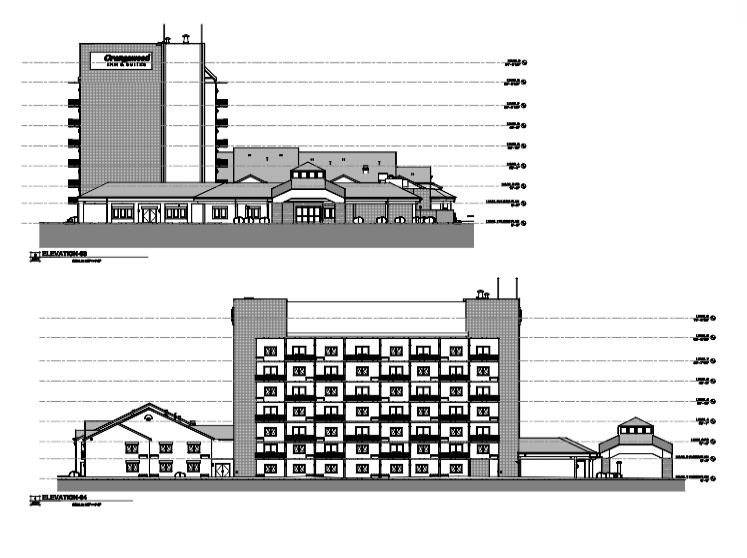
Typical Projects: existing commercial buildings, 50,000SQFT and above. Hotels, warehouses, distribution centers and large commercial properties.
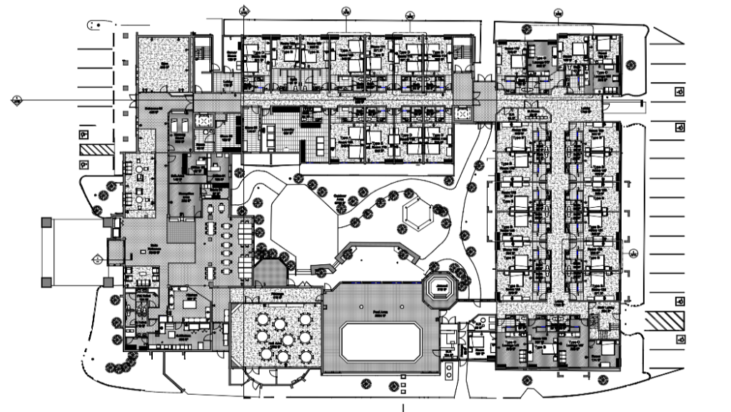
Most of our work is on warehouses, distribution centres, hotels, and large commercial buildings. Typically existing properties where the original drawings are 20 or more years old, partially missing, or no longer match what’s actually built. We use 3D laser scanning to capture the building as it really is today, then turn that data into clean drawings your design team, leasing agent, or facilities manager can rely on.
From site measure to delivered drawings, one point of contact the whole way.
On every Measured Building Survey project, you’ll work directly with Michael Kiernan, GeoMaus’s founder, from the first call to the delivered drawing set. No project coordinators relaying messages, no waiting for someone to check with someone else. When something changes or a deadline shifts, you’re speaking directly to the person who can make the call that day.
Complete drawing set plus 3D data for future building design work.
Accurate floor plans showing walls, doors, windows, structural openings, and room names. Annotated to your layer standards. The foundation of every measured building survey for any building type.
External and internal elevations with level datums, material indications, and opening dimensions. Essential for building surveying and planning submissions.
Structural sections showing floor-to-ceiling heights, beam positions, and construction details. Critical for full measured building surveys of complex buildings.
Full reflected ceiling plans containing all electrical, mechanical and plumbing layouts, fixtures and more.
Area calculations for lease documentation, valuation, and planning. Standard for commercial building surveys and building portfolio management.
Registered, georeferenced point cloud in E57 and RCP formats. Compatible with Revit and CloudCompare. Enables future Scan to BIM or Scan to CAD workflows for the building.
Most measured building survey projects we’re called in on fall into one of these situations. If yours is on this list, you probably need documentation before the next decision gets made.
Construction never matches the original design exactly. As-built documentation records what was actually built so the building owner and operating teams have a current, dispute-resistant record going forward.
You’ve inherited a building with no drawings, or drawings that don’t reflect what’s there. A new as-built package gives you a current baseline you can plan from.
Insurance, defect liability, and contractual disputes turn on verifiable measurements. As-built drawings captured from scan data give you a documented record that holds up under scrutiny.
You need a permanent digital record of the building for asset management, maintenance planning, and lifecycle decisions. As-built documentation becomes the foundational reference for the next 20 years of decisions.
Before redesigning the building, you need to know what’s actually there. Verified as-built drawings give your design team the dimensional baseline they need.
Not sure if your project fits? Book a 30-minute call with Michael. If measured building survey isn’t the right answer, he’ll tell you on the call.
Everything you need to know about our building surveying workflow, accuracy, and deliverables.