Hotels and Hospitality

125-Room Hotel Full Measured Survey with Drone-Captured Elevations – Kansas City, MO

Full LiDAR capture and scan-to-BIM documentation of a 125-room, 7-story hotel near Kansas City Airport, combined with a drone measured survey to accurately capture building heights and elevations beyond the reach of ground-based scanning, completed in 3 days on site to support a brand-compliance renovation and PIP.

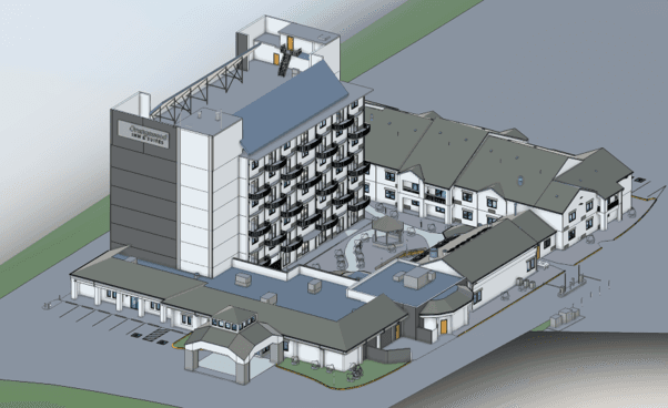
The Orangewood Inn Measured Survey - Full revit model and CAD documentation
The Orangewood Inn & Suites Kansas City, MO.
LOCATION(S)

Kansas City Airport (KCI) area, Kansas City, MO.

APPROXIMATE SIZE

7-story hotel, 125 guest rooms

BUILDING TYPE

Hotels and Hospitality

SERVICES: 3D LiDAR Laser Scanning 3D Virtual Tour BIM Modelling Drone Measured Survey Measured Building Survey
DELIVERABLES: CAD Drawings Coordinated Revit Model Exterior Elevations Floor Plans Full 3D Virtual Tour Reflected Ceiling Plans Registered Point Cloud

THE CHALLENGE

Seven Stories of Elevation Ground-Based Scanning Couldn't Reach

An Orangewood Inn & Suites property near Kansas City Airport needed full existing-conditions documentation to support a renovation and Property Improvement Plan (PIP) for brand compliance. As with our other hotel PIP surveys, the interior scope was extensive -125 guest rooms across seven floors, plus every common area, staff area, and exterior condition, all captured without disrupting an occupied, operating hotel.

The added challenge on this one was the building’s height. At seven stories, the upper elevations and roofline detail simply weren’t accessible or accurately measurable from ground-based LiDAR alone as the angles and distances involved would have meant gaps or inaccuracies exactly where the PIP needed precision most. Capturing those upper elevations accurately required a different capture method entirely, on top of the same tight 3-day site window as our other hotel projects.

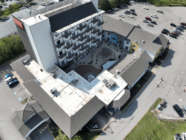
Kansas City Airport Hotel - Drone scanning - existing conditions as built measured survey with cad documentation
The Orangewood Inn & Suites KCI property, captured via combined LiDAR and drone survey.

SCOPE OF WORK

What We Delivered

The brief covered the full interior of the property – every guest room, common area, staff and back-of-house space – alongside complete exterior elevations of the 7-story building. Because the ground-based scan couldn’t safely or accurately capture the upper floors’ height and roofline detail, the scope was expanded to include a drone measured survey specifically to record accurate building elevations from top to bottom.

The client needed both datasets brought together into a single coordinated Revit model to support the renovation design, backed by full CAD documentation, including floor plans, reflected ceiling plans, and elevations, and a complete 3D virtual tour of the property.

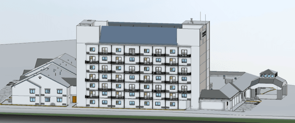
Coordinated BIM / Revit Model - Orangewood inn and suites - measured survey
Coordinated elevation model combining ground LiDAR and drone survey data.

OUR APPROACH

Ground LiDAR Below, Drone Survey Above

Interior spaces including all 125 guest rooms, common areas, and staff areas were captured with 3D LiDAR scanning at millimetre-level accuracy, sequenced floor by floor to avoid disrupting hotel operations during the 3-day site window. For the building’s exterior, ground-based scanning alone couldn’t reliably reach the upper elevations of a 7-story structure, so we deployed a drone measured survey to capture accurate heights and elevation detail across the full facade, from ground level to roofline.

The two datasets  interior point cloud and drone-captured exterior were registered together and processed as a single coordinated model. Our BIM team then produced a fully coordinated Revit model, complete CAD floor plans, reflected ceiling plans, and exterior elevations, checking every deliverable against the source data to ensure the drawings would hold up to brand-compliance review.

THE OUTCOME

Accurate Elevations, Top to Bottom, in Three Days

Complete as-built documentation – CAD, PDF, and a coordinated Revit model covering all 125 rooms, common areas, staff areas, and full exterior elevations – was delivered along with a full 3D virtual tour of the property. By combining ground-based LiDAR with a drone measured survey, the client received accurate elevation data across all seven stories that a single capture method couldn’t have delivered on its own, completed within the same 3-day site window as our other hotel projects.

For a property working toward a brand-compliance renovation, the value was a complete and accurate dataset  interior and exterior giving the design team the confidence to plan the full scope of the PIP without gaps in the elevation data that could surface as problems later in the renovation.

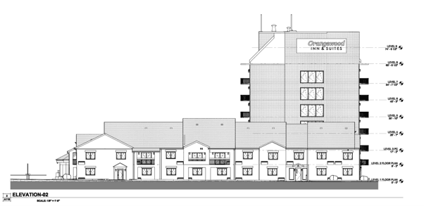
CAD Documentation - Exterior elevation captured with Drone scanning
Final exterior elevations from drone and lidar measured surveys

RECENT WORK

Recent Case Studies

From operational hotels and distribution centres to commercial portfolios and industrial facilities, explore how GeoMaus has helped clients create accurate building documentation while maintaining clear communication, dependable delivery and minimal disruption to operations.
200 Chambers Street NYC – Restaurant Fit-Out Survey, Tribeca

Full LiDAR capture and scan-to-BIM documentation of an irregularly shaped restaurant space at 200 Chambers Street in Tribeca, delivered in a 12-day turnaround with full floor plans, elevations, and coordinated reflected ceiling plans ahead of fit-out.

Pittsburgh, PA – 148-Room Hilton-Brand Hotel Full Property Survey

Full LiDAR capture and scan-to-BIM documentation of a 148-room, 5-story Hilton-brand extended-stay hotel in Pittsburgh’s Southpointe area, covering guest rooms, common areas, staff areas, and exterior elevations, completed in 3 days on site with zero disruption to the occupied property, to support a brand-compliance renovation and PIP.
Times Square NYC – 30,000 Sq. Ft. Office Floor Measured Survey

Full LiDAR capture and scan-to-BIM documentation of a vacant 30,000 sq. ft. office floor in a landmark Times Square building, delivered design-ready with no revisions.

Hudson Yards NYC – 6,000 Sq. Ft. Restaurant Fit-Out Survey

Full LiDAR capture and scan-to-BIM documentation of a 6,000 sq ft commercial space in Hudson Yards, delivered in a 12-day turnaround from a single access window, with detailed reflected ceiling plans to map a complex open-ceiling condition ahead of retrofit.

REQUEST A FREE QUOTE

Tell Michael About Your Project

Most enquiries get a same-day reply from Michael directly. If your project isn’t a fit for us, he’ll tell you on the call and point you somewhere better.

No sales calls, no automated drip sequences. Michael replies personally to every enquiry usually within a few hours.