Luxury Residential

Measured Survey in Baldoyle, Dublin: Three-Level Home to Revit

Measured Survey and Revit modeling for a home in Baldoyle, Dublin. An architecture practice working for the homeowners wanted existing drawings to support a feasibility study and a possible planning application. Our measured building survey produced DWG and PDF plans, elevations and sections, a site plan, a Revit model, a virtual tour and the raw point cloud data.

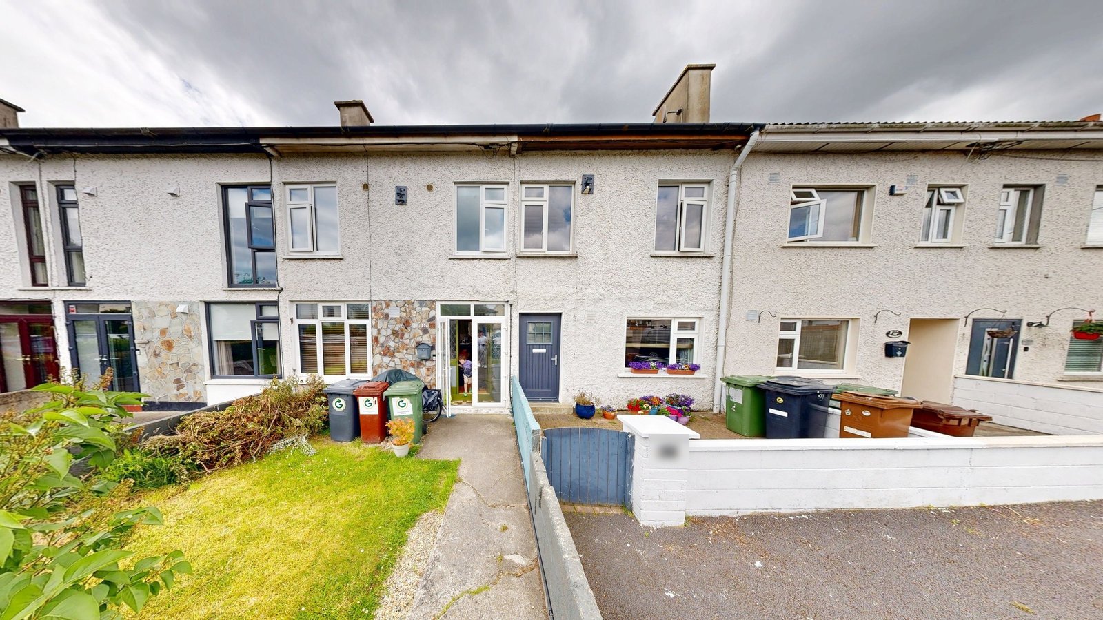
Row of rendered terraced houses in Dublin with stone cladding at ground level and front lawns
Front of the Baldoyle terrace, with pebbledash, stone cladding and low front walls.
LOCATION(S)

Baldoyle, Dublin

APPROXIMATE SIZE
BUILDING TYPE

Luxury Residential

SERVICES: 3D LiDAR Laser Scanning 3D Virtual Tour Architectural CAD Documentation Measured Building Survey Scan-to-BIM
DELIVERABLES: CAD Drawings Coordinated Revit Model Exterior Elevations Floor Plans Full 3D Virtual Tour PDF Drawing Set Registered Point Cloud Sections Site Plan

THE CHALLENGE

Baldoyle Measured Survey Ahead of a Home Feasibility Study

Before sketching any options for this Baldoyle home, the homeowners’ architecture practice needed a dependable picture of the building as it stands. The work was framed as a feasibility study, with a planning application possible later, so GeoMaus was brought in to measure first, as we do across our Dublin survey work.

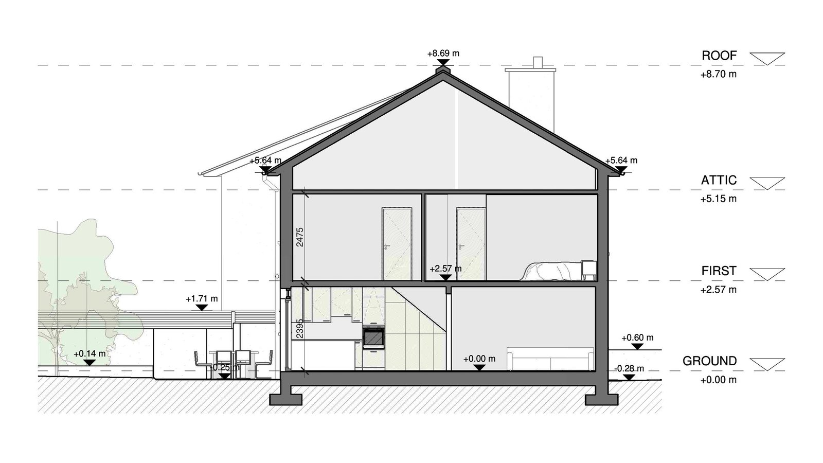
Three levels made the record harder than a single plan. The ground floor, the first floor and the attic each had to line up with the others, and the outside walls had to sit correctly on the plot, so any option drawn later would rest on one consistent base.

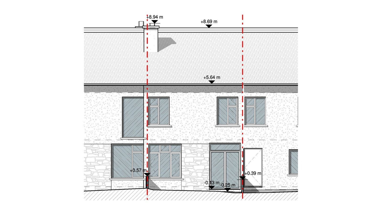
Existing front elevation drawing of a terraced house with a stone base and level markers
Front elevation of the Baldoyle house with level marks at the eaves and the ridge.

SCOPE OF WORK

Existing Conditions of a Ground Floor, First Floor and Attic

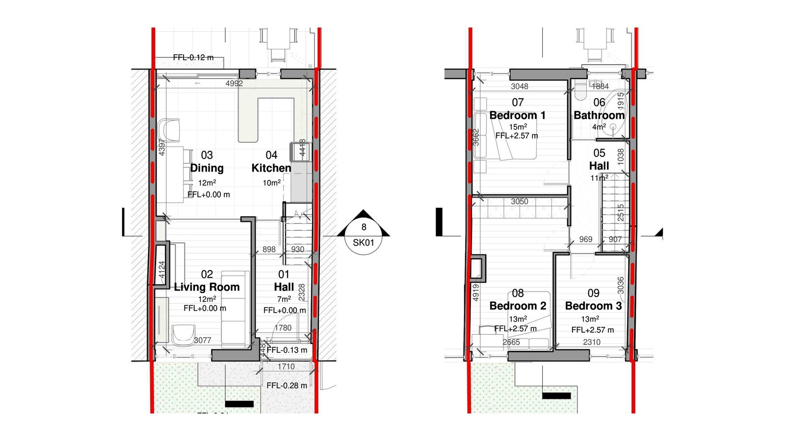
The brief asked for every accessible room on all three levels, the external facades and the site around the house. From that one record the practice wanted floor plans for each level, exterior elevations, sections, and a site plan showing the house within its boundaries.

Feasibility drawings only help if every drawing agrees, and a later planning submission would lean on the same base. That is why the deliverables paired a Revit model with DWG files and a PDF set, giving the architects as-built documentation they could use in their own software from the first sketch onward.

Existing ground and first floor plans of a terraced house with room names and areas
Ground and first floor plans of the Baldoyle house, with each room named and its area noted.

OUR APPROACH

Single-Visit Matterport Capture Inside and Around the House

The survey took a single visit. We started outside, recording the facades and the plot, then moved through the ground floor rooms, climbed one level and finished in the attic, all using LiDAR scanning with the Matterport Pro3. The sweeps also became a Matterport 3D tour the architects could revisit whenever a question came up.

In the office, those sweeps were stitched into a single registered point cloud. Our modelers traced walls, openings, floors and the roof directly from it in Revit, so the model and every drawing share one geometry. Because everything came from one source, the feasibility options could be measured against the same numbers.

Section drawing of a two-story house with an attic showing floor levels and the roof pitch
Baldoyle section cutting through all three levels, with the attic under the pitched roof.

THE OUTCOME

Revit, DWG and PDF Files for Feasibility Planning

The homeowners’ architects received the coordinated Revit model, a full set of DWG drawings and a matching PDF set covering the site plan, floor plans, sections and elevations. The raw point cloud data came as one registered file, along with the full virtual tour, so dimensions could be checked without another trip to Baldoyle.

With the house modeled as it stands, the practice could test layouts on all three levels and carry the preferred option into planning drawings if the project moves ahead. The scan-to-BIM model stays useful beyond feasibility too, giving later stages a starting point inside the same file.

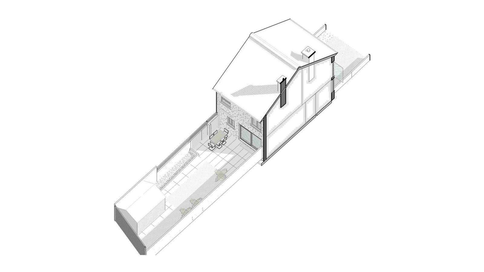
3D Revit model of a terraced house seen from the rear with its long plot
Rear view of the Baldoyle Revit model, with the long back plot and its boundary walls.

RECENT WORK

Recent Case Studies

From operational hotels and distribution centres to commercial portfolios and industrial facilities, explore how GeoMaus has helped clients create accurate building documentation while maintaining clear communication, dependable delivery and minimal disruption to operations.
Bangor, ME – Hotel As-Built Survey & Scan-to-BIM for Renovation

Existing conditions survey and scan-to-BIM documentation for a hotel near Bangor International Airport in Maine. The project combined a Revit model, CAD drawings, PDF documentation, and a Matterport 3D virtual tour to support renovation planning, room-by-room quantity takeoffs, and kitchenette feasibility across 25 guest rooms.

Columbus, OH – 10,398 Sq. Ft. Restaurant Matterport Survey & Revit As-Builts

Matterport capture and Revit as-built documentation for a 10,398 sq. ft. restaurant in Columbus, OH. The surveyed floor holds eight serving areas, a bar, and two kitchens inside an irregular footprint. GeoMaus produced a Revit model, CAD and PDF drawings, point cloud data, and a Matterport 3D tour.

Newark, NJ – 2,547 Sq. Ft. Home Measured Survey & CAD As-Built Drawings

Measured building survey and CAD as-built drawings for a 2,547 sq. ft. two-story home in Newark, NJ. A residential design firm needed the house drawn to its own CAD standard. GeoMaus captured the property with a Matterport Pro3 and delivered plans for three levels, elevations, sections, a roof plan, and door and window schedules.

Bayside, Dublin – Three-Level House Existing Drawings & Revit Model

Existing drawings and a Revit model for a three-level house in Bayside, Dublin. The homeowner’s architects needed the existing conditions measured for a feasibility study ahead of a possible planning application. The measured building survey produced a Revit model plus floor plans, elevations and sections in PDF and DWG, with a site plan.

REQUEST A FREE QUOTE

Tell Michael About Your Project

Most enquiries get a same-day reply from Michael directly. If your project isn’t a fit for us, he’ll tell you on the call and point you somewhere better.

No sales calls, no automated drip sequences. Michael replies personally to every enquiry usually within a few hours.